Renfrew-Collingwood Community News

News stories from the Renfrew-Collingwood community in East Vancouver


1 Comment

Skytrain Rambler: Evergreen line connects history from Renfrew-Collingwood to Port Moody

BY JULIE CHENG

As a young boy my husband lived for a while in Port Moody. Since the opening of the Evergreen Skytrain extension in December 2016, I’ve been thinking of visiting that area of the Lower Mainland. Along with tracing the roots of my husband’s childhood, I discovered history connections between Port Moody and our little corner of Vancouver, Renfrew-Collingwood.

Skytrain Station: Renfrew station at East 12th Avenue/Hebb and Renfrew to Inlet Centre Station. Travel time: 28 minutes. Roundtrip with a walk in between takes two to three hours.

Evergreen_Line_map

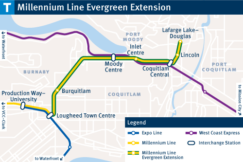
From Renfrew station, take the Lafarge Lake-Douglas train going east and stop at Inlet Centre Station. Source: Translink

From Renfrew station, take the Lafarge Lake-Douglas train. Along the way you’ll pass by Brentwood Mall, Production Way-University and Lougheed Skytrain stations, interspersed with industrial warehouses. At Burquitlam you can see the east side of Simon Fraser University on top of the hill before entering a tunnel that will take you into Port Moody.

As you glide into Inlet Centre Station, you’ll notice the railcars sitting on the tracks running parallel to the Skytrain line.

Port Moody Train

The railway figures prominently in Port Moody history. Photos by Julie Cheng

Port Moody is a historical railway town. As a port, it was the original destination for the railway terminus for the Transcontinental Railway (CPR) before land speculators got a hold of it and moved it to Vancouver where the Seabus building now stands. Apparently Port Moody didn’t have enough flat land to put the railyards, says my history-buff husband. This is why we have the tunnel (now the Skytrain tunnel) to Yaletown, which became the railyard flats.

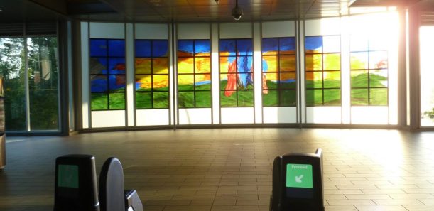
Check out the artwork inside and outside Inlet Centre Station before you turn left and follow Ioco Road to Sherbrooke. Turn left at Suter Brook Village and go through the village. This is your chance to grab a juice or coffee before your trek.

[photo 4] Check out the artwork inside and outside Inlet Centre Station.

Check out the artwork inside and outside Inlet Centre Station.

Cross Murray Street and go left, following the bike trail. Along the edge of the wooded area you’ll see nurse stumps, which are tree stumps left over from old forestry logging. Take the Sutter Brook Creek trail and go through the community centre parking lot with tennis courts on your left. Pass by the Trasolini soccer field and you’ll see a trailhead straight ahead. Go right and follow the rail lines with the soccer field to your right. Cross the railway line and follow signs into Shoreline Park.

The map shows you can turn right to Old Orchard Park, where you’ll see old logging equipment along the way, or you can turn left to Rocky Point Park, which loops you back into Port Moody.

From the map, we head straight and found we had met up with the TransCanada Trail. In front of us are mud flats – the head of the Burrard Inlet and a tidal area. My husband remembers as a three year old walking with his dad across the mud flats at low tide from his house on Ioco Road all the way to Rocky Point (now marked by a large green shed that’s a sulphur storage plant).

The tidal mud flat in Shoreline Park is at the head of Burrard Inlet.

The tidal mud flat in Shoreline Park is at the head of Burrard Inlet.

Turning left across a small bridge onto the TransCanada Trail, destination Rocky Point, you’ll see the mud flats become marsh. My husband imagines native peoples living in middens throughout this area, with its rich food sources from the sea. This is where the sea meets fresh water, and an area that salmon would travel on their way to their spawning grounds. It’s important to catch the salmon close to the sea as salmon start to deteriorate once they hit fresh water.

It’s a leisurely walk over boardwalk and trail along the edge of the water. Take your time reading the TransCanada Trail signs and learning about local history and flora and fauna.

It’s a leisurely walk over boardwalk and trail.

It’s a leisurely walk over boardwalk and trail.

Rocky Point has a children’s playground and a nice wharf. It’s still a working waterfront, with an active mill near the wharf. A sign at the beginning of the wharf tells the history of Port Moody’s namesake, Colonel Richard Moody. “You know,” my husband says, “Colonel Moody and his ‘sappers’ did all the surveying in Collingwood.” A quick search confirms this tidbit of history (see box).


My husband remembers walking with his father clear across the inlet from Ioco Road to Rocky Point as a young boy.

My husband remembers walking with his father clear across the inlet from Ioco Road to Rocky Point as a young boy.


Pajo's at Rocky Point

Feeling hungry from your walk? This is a perfect time stop by for “world-famous” fish and chips from Pajo’s.

By now you may be ready to head home, or you can head into Port Moody to see what the shops and restaurants have to offer. To head home, take the overpass. To the right is the Port Moody Railway Museum and to the left is the Moody Centre Skytrain station, around five minutes’ walk from Pajo’s.

On the way back we transferred at Lougheed Station and took the Expo line back to Collingwood. Just walk across the platform at Lougheed and take the Expo line train heading to Waterfront.

Along the way we saw more working waterfront. Around Sapperton (named after Colonel Moody’s sappers) in New Westminster there’s the hospital and the Brewery District, where Labatt’s Brewery used to be. To your left up the hill is the former B.C. Penitentiary, opened in 1878 and closed in 1980. Just before you pull into New Westminster station you’ll pass the red brick buildings of the New Westminster courthouse, first built in 1891.

New Westminster, too, was established before Vancouver in the 1859 and for a short time was the capital. Kingsway was a trail and the quickest way from New Westminster to Vancouver.

Before rolling into Royal Oak station, I look south for the ocean views and the Gulf Islands in the distance. So much more history to discover.

Julie Cheng loves taking the Skytrain. She has been the editor of the Renfrew-Collingwood Community News for 10 years.

Colonel Moody and Collingwood

According to the Collingwood Neighbourhood House:

“In the 1860s Colonel Richard Moody of the Royal Engineers took a fancy to a lake that sat between what are now Kingsway and Vanness Avenue. He laid claim to the lake and the surrounding land. Moody and other early European settlers were attracted to this area because they were able to drain the lake and grow food in the fertile soil.

“Kingsway, once part of an early military trail to Burrard Inlet, follows the route of earlier Aboriginal trails that ran parallel to the lake shore. Streets in the neighbourhood were built in orientation to Kingsway and are therefore at odd angles with the rest of Vancouver’s grid-like layout.” (www.cnh.bc.ca/neighbourhood-stuff-to-do/neighbourhood-history/)

Copyright (c) 2017 Renfrew-Collingwood Community News


Leave a comment

August 2017 issue of RCC News is here

Renfrew-Collingwood Community News August 2017

This issue of the Renfrew-Collingwood Community News is full of the many wonderful people, events and programs happening in our neighbourhood!

Get your latest issue of the RCC News at your local coffee shop, grocery store, library and community centre.

Or click on the cover image to view the new issue.

In this issue:

  • Skytrain Rambler: Evergreen line connects history from Renfrew-Collingwood to Port Moody
  • Lots happening at Still Moon Arts Society
  • Photos of informal learning in Renfrew-Collingwood by John Mendoza
  • Homeless program raising funds in the neighbourhood
  • Shop local farmers markets
  • Gathering of canoes – Photo montage by Penny Lim
  • Read On! Many reasons to love Renfrew-Collingwood by Tony Wanless
  • Latin festival returns to new venues – Swangard Stadium and Rickshaw Theatre

Do you have a local story to tell or an event to share? We’d love to hear about it! Email rccnews-editorial@cnh.bc.ca.

The deadline for the September 2017 issue is August 10. We welcome story submissions from 300 to 400 words long. Accompanying photos must be high resolution in a jpg file at least 1 MB large and include a photo caption and the name of the photographer.


Leave a comment

Skytrain Rambler: Stop at Sperling-Burnaby Lake to see baby ducks and geese

More reasons to ♥ Skytrain

BY JULIE CHENG

Burnaby Lake Geese

A spring-time ride to the Sperling-Burnaby Lake Skytrain station takes you to the delightful baby geese that make their home at Burnaby Lake. Photos by Julie Cheng and Bryden Fergusson

I’ve said it before, I’ll say it again: I love the Skytrain. With two lines (Expo and Millennium) running through it, Renfrew-Collingwood has more Skytrain stops than any other community. The Skytrain can take you downtown and on to the North Shore by Seabus, east to Burnaby or Surrey, and south to Richmond.

The Skytrain saved me years ago when I was feeling isolated at home and searching for places to go with my two preschool kids. I’d pack them in the stroller and take the Skytrain to the family drop-in at Collingwood Neighbourhood House, the storytimes at the Central Branch library and onto the Seabus for a walk along the North Vancouver seawall.

Today the Skytrain gives my teenage kids freedom to move around the Lower Mainland. Sadly for me but happily for them, Skytrain takes them to the shops and restaurants on Robson Street or at Metrotown.

April is the perfect time to get outside and enjoy the sunshine. Hop on and take a Skytrain ride to a lovely spot in Burnaby that is linked by nature to Renfrew-Collingwood. You’ll see baby ducks and geese and more!

Skytrain stop: Sperling-Burnaby Lake

Zone 2 on the Millenium Line; about 10 minutes from Renfrew or Rupert Station OR 30 minutes from Nanaimo, 29th Avenue or Collingwood-Joyce Station. The longer route takes you past the beautiful waterfront of Sapperton in New Westminster.

Sperling-Burnaby Lake Skytrain Station Stained glass

The beautiful light from the stained glass greet you in the Sperling-Burnaby Lake Skytrain Station.

From the Sperling-Burnaby Lake station, it’s an easy 10-minute walk to Burnaby Lake and its lovely calm waters that are fed by Still Creek. This is the same creek that flows through our neighbourhood’s Renfrew Ravine.

Before coming out of the station, enjoy the beautiful light coming from the station’s stained glass. Then head south (away from the mountains) and take the overpass, where you’ll be rewarded with a glimpse of Still Creek and other great views.

Overpass to Burnaby Lake

You get great views from the overpass.

Bridge View

Follow the Central Valley signs to Burnaby Lake. Pass by the target range for the Burnaby Archery Club and head to the back side of the Burnaby Lake Sports Complex (includes the Bill Copeland ice rink).

Central Valley signs to Burnaby Lake

Follow the Central Valley signs to Burnaby Lake.

You’ll soon find one of the entrances to Burnaby Lake. Ahead of you is a path leading across a bridge and to your right another path leads to a large open field where people can be found flying model airplanes whenever the geese are not around. It’s your choice which route you take. Either one will take you around the lake’s entire 11 kilometres of trail.

You can download a map of Burnaby Lake Regional Park to help you get around.

Boats at Burnaby Lake boat house

You’ll see colourful boats and a gorgeous view of Burnaby Lake from the boat house.

If you don’t have much time to walk around the whole lake, continue to the right past the large field. You will cross a parking lot and across the boat house. The boat house (actually called a rowing pavilion) and spectator stands were built for the rowing events during the 1973 Canada Summer Games. More recently rowers trained here for the 2012 Summer Olympics, and the last time I visited, there was a wedding in full swing in the beautiful boat house. From here people also launch their rowboats or kayaks.

Skytrain is a fast, efficient and environmentally friendly option for transportation. It saves you parking and gas, and best of all, lets you enjoy beautiful natural spaces like Burnaby Lake.

Bird boat house

In addition to baby ducks and geese, Burnaby Lake is a great place to spot blue herons, bald eagles, kingfishers and osprey.

Julie Cheng is the editor of the Renfrew-Collingwood Community News. This story was first published in the April 2015 issue.

Copyright (c) 2017 Renfrew-Collingwood Community News